We will survey all accessible floors in the property and provide plans showing all visible walls, windows, doors, spot height levels, ceiling/roof heights, window sill/head heights.
MEASURED BUILDING SURVEYS
We can turn around measured building surveys in as little as one working day. We use an advanced technology which means we can offer measured surveys with an accuracy of +/- 2mm.
- From contact to booking within as little as 48 hours
- Properties with up to five bedrooms can be surveyed within one day
- For properties with more than five bedrooms we require at least one day
A measured survey is a process that involves taking the exact measurements of buildings and sites. We offer measured building surveys using equipment accurate to +/- 2mm. The results of measured surveys are represented through drawings which can be referred to throughout the lifecycle of a building. Book an instant quote now, to receive your personalised costing.
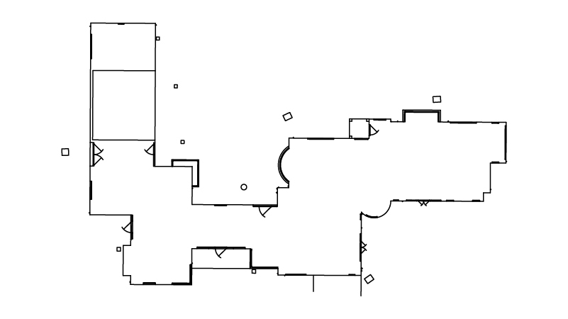
Floor Plans
We will survey all accessible floors in the property and provide 2D plans showing all visible walls, windows, doors, spot height levels, ceiling/roof heights, window sill/head heights. Note, that if a loft plan is required, safe access is to be provided. We will not access loft areas that are not boarded. Safe access and adequate lighting will need to be provided if any basement space is to be measured.
Example floor plan:

Roof Plans
Will only be provided where our equipment has full visibility of the roof lines from ground level. We will note any estimated roof details on our drawings. For a more accurate roof plan why not consider upgrading to a ‘Roof Survey’ where we can use drone technology to access areas not visible from ground level.
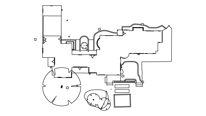
Elevations
We will survey all accessible and visible sides of the property and provide 2D elevation drawings showing the building outline, ridge/eaves heights, all external distinguishing elements such as windows, doors, rainwater pipes and other detailing. We will also include the outline of buildings within 3m of the host building.
Example elevation:

Sections
These are ‘cut-through’ cross-sectional drawings showing wall and floor details.
Example section:

TOPOGRAPHICAL SURVEYS
Topographical surveys comprehensively and accurately assess a site or section of land, taking into account considerations that relate to a specific planned future development.
- Our topographical surveys identify and assess the limitations of your site
- Topographical surveys are useful for architectural practices and property developers, as well as
- homeowners that wish to assess the value of their property or land
- XP Surveys use technology that is accurate to within +/– 2mm
Our topographical surveys are extremely accurate and thorough, taking into account all possible considerations that could prevent a planned property development. Using our specialist equipment, our CAD surveys can be output in AutoCAD (.DWG), Revit (.RVT) or PDF formats. Prices are available on request, as we treat every topographical survey as bespoke.
We offer three types of topographical survey: Basic, Mid-Level and Full.
Basic
This topographical survey will include the visible boundary outline only together with immediate ground levels around any buildings, and visible drainage cover location/levels
Mid-level
This topographical survey will include the visible boundary outline, all key features and immediate ground levels within 3m of any buildings, and visible drainage cover location/levels
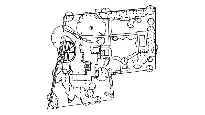
Full
This topographical survey will include boundaries (including type and heights), building OUTLINES, adjoining buildings (plus eaves / ridge heights where visible), trees / groups of trees (including trunk diameter, spread, height), hardstandings (including surface types), watercourse (including direction of flow, water level time and date), banks, retaining walls, walls, fences (including heights & types), hedges, flowerbeds, structures (including description), kerblines, verges, street furniture, manhole / service covers (including cover level), etc. plus all other visible salient features of the area.
Example full topo:

ROOF SURVEY
Checking the condition of your roof will help you understand any potential remedial works required or help you spot future issues like loose tiles or broken guttering. It can also be a requirement of your insurance provider. Our drone roof surveys give you the full picture without paying for expensive scaffolding, or creating health and safety access issues.
DRAINAGE SURVEY (CCTV)
Check the condition of your underground drainage pipework using specialist cameras and get a detailed report of any issues together with a list of recommendations to replace/repair/unblock the faulty drainage. Broken pipes and uncertain drainage conditions can add delays and costs to any home improvement project if not uncovered early. Make sure you understand the direction, depth and condition of your drainage before starting works on site by undertaking this CCTV Drainage Survey.
Price may increase for properties above 6-bedrooms.
360 VIRTUAL TOUR (MATTERPORT)
The perfect service for Estate Agents, Architects, Contractors, Developers, Landlords and anyone who wants to record a full digital twin of a property for future reference. No more wasted viewings or trips to site. Show your ‘before’ and ‘after’ projects by undertaking a tour at numerous stages in your project. Showcase your property overseas and remotely to anyone with a phone or computer.
Matterport gives you an immersive online 3D experience like no other!
- Industry-leading technology
- Property scanned with the Matterport Pro Camera
- Virtual Matterport Space ready to experience within hours
- Inside View Navigate
Matterport allows easy exploration from your own browser. With Inside View Navigate akin to a video game with Inside View. Multiple Views including Dollhouse and Floorplan View make this a very useful and highly detailed option. Prices are available on request.
Free hosting for 3-months (can be extended for £10/month thereafter).
DRONE SURVEYS
Drone surveys utilise technology enabling the construction world to easily visualise alternative options that otherwise may have been extremely time-consuming to obtain or not even possible.
- Our drone surveys capture hard-to-reach areas quickly
- Drone Surveys are a huge time saver in gathering visuals where scaffolding or high-reach equipment would be needed otherwise
- Drone Surveys massively reduce Health & Safety implications by negating risky inspections with non-personnel direct involvement
- XP Surveys use technology that is accurate to within +/– 2mm
Our drones provide and create real-time visuals to enable accurate and thorough surveys. Prices are available on request.
SPEEDY DELIVERY!
If you’re in a rush and need your survey output quickly, we can provide a speedy delivery for an additional cost. Enquire with one of our team for more information.
HARD COPY PRINTS
Order physical black and white A1 prints to your door. Any additional prints will be charged at £3 per page in your final invoice. Most houses up to 6-bedrooms only require 3 pages.