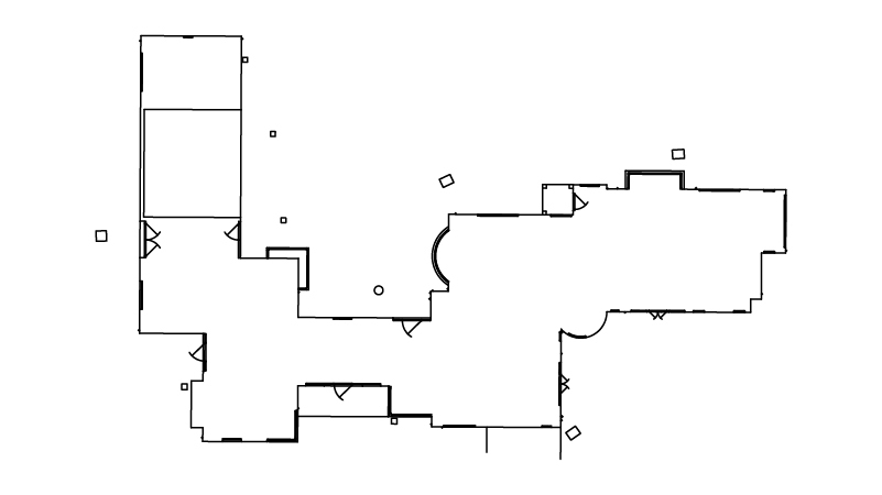
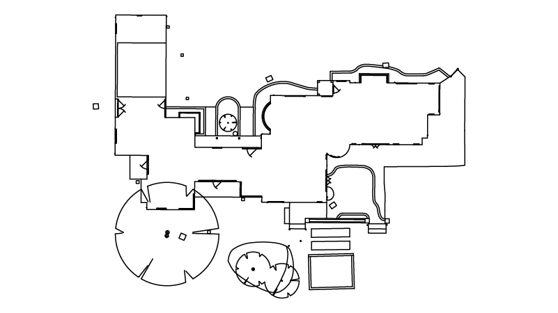
We will survey all accessible floors in the property and provide plans showing all visible walls, windows, doors, spot height levels, ceiling/roof heights, window sill/head heights.
Measured Building Surveys South Oxfordshire
How Much Does A Measured Survey Cost?
With offices in Reading and in London, we are a great choice to consider if you need a measured building survey in London, Didcot, Henley-on-Thames, Thame, Abingdon, or the Wallingford area. You can benefit from our professionalism, rapid turnaround times, reliable service, and accurate drawings and get an instant measured survey cost using the calculator tool above here and now.
If you are wanting more information or a measured building survey cost, please get in touch with us today. Ring 0333 335 5085, email info@XPsurveys.co.uk, or fill out our online quote request form. Alternatively, you can also view our locations page here.
Our Services
Introducing XP Survey
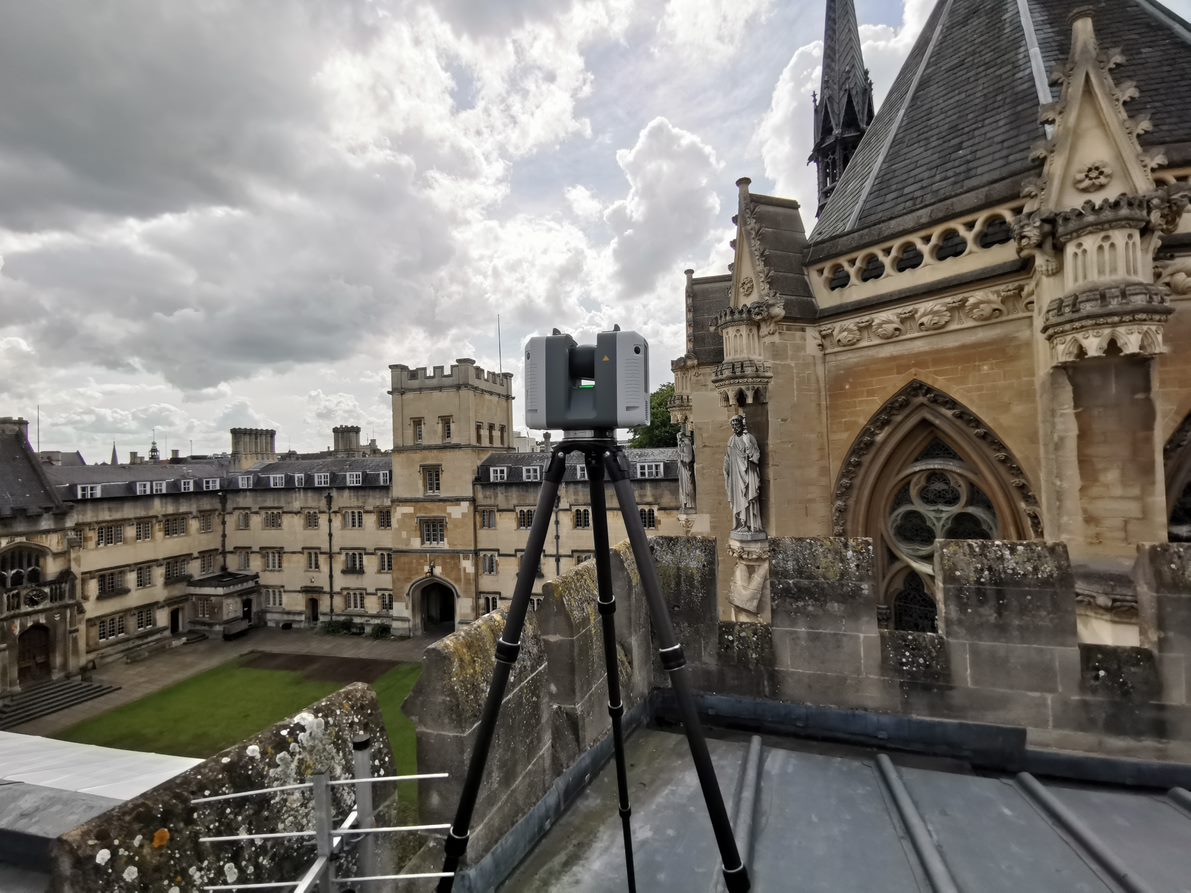
We offer measured building surveys using Lecia equipment accurate to +/- 2mm. We work quickly and typically can book you in within 1-2 days of you getting in touch with us. We can finalise your drawings within five working days from the date of your survey booking.
For some projects we carry out optional REVIT Models, providing 3D drawings to really bring your project to life. This service is suitable for architects, structural engineers, building designers, and contractors.
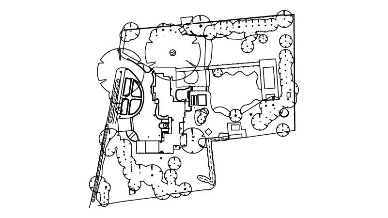
We can also help you understand the details and exact location of boundaries, natural and manmade features, and contours within a plot of land with a topographical land survey, to inform your project.
4 Easy Steps
1
You Enquire
We ask for the address and a few questions about the project.
2
Instant Quote & Book
You receive an instant measured survey cost and book in your survey at a time that suits you via our online booking system on this page.
3
We Survey
We conduct the survey and process the data.
4
Receive Drawings
We plot your surveys in 2D or 3D and send to you in your chosen format.
Our Clients
Architects & Designers
Property Developers
Engineering & Construction Companies
Commercial Property Owners & Agents
Homeowners
Commercial
We provide accurately measured topo surveys for the commercial sector, whether you need to submit a planning application or a lease plan, keep a record of as-built drawings, or to start work on redesigning your property.
We work with:
- Architects
- Surveyors
- Property developers
- Construction companies
- Commercial property owners
You can view planning applications on the South Oxfordshire Council’s website.
Homeowners
We work with homeowners across the region of South Oxfordshire to measure a range of residential properties, sizes from one-bedroom properties to large houses above 1,000m². One full day on site is required for surveying properties of up to five bedrooms, with CAD survey drawing production completed within five working days.
106
surveys completed
350
drawings issued
1.2M
laser scans captured
FAQ
What are measured surveys?
A measured building survey is a process which involves taking the exact measurements of buildings and sites. Our surveys are carried out using equipment accurate to +/- 2mm. The results of these surveys are represented through drawings which can be used as submissions for estate agent plans, architectural drawings, planning permission and lease plans.
How long does a measured survey take?
A survey can be booked within 48 hours of getting in touch with us (subject to availability). We require one full day on-site for properties up to five bedrooms. Properties of five bedrooms or more will take at least one day.
How much does a measured building survey cost?
The price will vary depending on the size of the property. Get an instant quote above.
What is a topographical study?
A topographical survey, or topo survey, is a way to identify and map the features of terrain in an outdoor area. This type of survey shows how the land is now and how it will look once construction is completed.
Building projects have deadlines to meet and involve a complex network of stakeholders and organisations, including architects, council planning departments, construction companies, and clients.
Good quality service aspects like turning up for the survey at the agreed date and time are an important consideration when selecting a firm to conduct a topo survey in South Oxfordshire for you.
What is 3D point cloud?
Where beneficial we use point cloud equipment to scan and measure every single point of your building or site to create pinpoint accurate 3D models. We use the latest high-tech, high-spec equipment to ensure accuracy each time.
What are as-built 2D drawings?
Using laser measurement and 3D point cloud technology, we produce 2D floor plans, elevations and sections, which are used to keep a record of newly built properties.
How can 360 imagery help me with my project?
360 imagery puts a virtual site tour within your reach at any time. We capture 360-degree images using our top-of-the-line scanning equipment. The 360-degree images save you time and resources as you can visit the site whenever you need without travelling.
What locations do you cover?
We work across Greater London and throughout the Home Counties:
- Berkshire
- Buckinghamshire
- Essex
- Hertfordshire
- Kent
- Middlesex
- Surrey
- Sussex
See our locations page to learn more about the areas we operate in and whether we can help you with a measured survey at your property.
Where can I see your prices list?
Use our instant quoting process to get an immediate cost estimate for your property.
Measured Building Surveys South Oxfordshire

Ben Richards, Director
Ben works to oversee the business and deliver high quality measured surveys in the Greater London area. He runs an architectural design company and has been in property development and construction for the last 12 years so understands what a good, measured survey looks like for architects and construction professionals.
Heather Adamson, Business Manager
As business manager, Heather ensures our operations run smoothly. Heather keeps us in line to ensure we are meeting client demands and achieving our goals.

Oscar Heath, Lead Surveyor
Oscar is our lead surveyor. He undertakes complex assignments, always meeting tight deadlines, to fulfil our promise of speedy service, while achieving superior quality levels for measured surveys and drone footage.
Testimonials
See what some of our clients have to say about our work to date.
5.0
Martin Piekarz
As a structural engineer, I have worked with XP Surveys on multiple projects and have always been impressed by quality of delivered surveys. Surveys are always accurate and delivered within timely manner, which allows design delivery process to go smoothly. Martin Piekarz CAD Engineering Solutions
J Smith
Excellent service, would highly recommend.
AURA Architecture
We've worked with XP Surveys on numerous projects, and each time their service has been fast, reliable, and their topographical and measured building surveys have always been highly accurate for our team to deliver projects. On a particular project, XP Surveys provided a highly accurate topographical drawing, which was vital as the existing property was on uneven landscape. Without a detailed and easy to read topographical and measured building survey, our team would have found...
Caolan Ryan
XP Surveys completed a topographical survey on a 6 acre greenfield site for Rectory Homes, a medium size developer in the south east. The topo was completed to a good standard with extensive detail. The whole process from recording on site to getting data in hand was a matter of days. We will be using XP Surveys again